格物
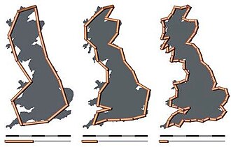
图:originals made by Avsa mixed by Acadac · CC BY-SA 3.0 · Wikimedia Commons
海岸线悖论
coastline paradox
counterintuitive observation that the coastline of a landmass does not have a well-defined length
The coastline paradox is the counterintuitive observation that the coastline of a landmass does not have a well-defined length or perimeter. This results from the fractal curve–like properties of coastlines, namely the fact that a coastline typically has a fractal dimension. Although the "paradox of length" was previously noted by Hugo Steinhaus, the first systematic study of this phenomenon was by Lewis Fry Richardson, and it was expanded upon by Benoit Mandelbrot.
摘自英文维基百科「Coastline paradox」(英文维基百科,暂无中文条目),CC BY-SA 4.0
- 类型
- 悖论
- 是……的一个方面
- 长度、fractal curve
百科正文
本条目暂无中文维基百科条目,下面是英文维基百科原文。
The measured length of the coastline depends on the method used to measure it and the degree of cartographic generalization. Since a landmass has features at all scales, from hundreds of kilometers in size to tiny fractions of a millimeter and below, there is no obvious size of the smallest feature that should be taken into consideration when measuring, and hence no single well-defined perimeter to the landmass. Various approximations, such as the Minkowski–Bouligand dimension, exist when specific assumptions are made about minimum feature size.
The problem is fundamentally different from the measurement of other, simpler edges. It is possible, for example, to accurately measure the length of a straight, idealized metal bar by using a measurement device to determine that the length is less than a certain amount and greater than another amount—that is, to measure it within a certain degree of uncertainty. The more precise the measurement device, the closer the results will be to the true length of the edge. With a coastline, however, measuring in finer and finer detail does not improve the accuracy; it merely adds to the total. Unlike with the metal bar, it is impossible even in theory to obtain an exact value for the length of a coastline.
In three-dimensional space, the coastline paradox is readily extended to the concept of fractal surface structures, whereby the area of a surface varies depending on the measurement resolution.
Discovery
Shortly before 1951, Lewis Fry Richardson, in researching the possible effect of border lengths on the probability of war, noticed that the Portuguese reported their measured border with Spain to be 987 km (613 mi), but the Spanish reported it as 1,214 km (754 mi). This was the beginning of the coastline problem, which is a mathematical uncertainty inherent in the measurement of boundaries that are irregular.
The prevailing method of estimating the length of a border (or coastline) was to lay out n equal straight-line segments of length l with dividers on a map or aerial photograph. Each end of the segment must be on the boundary. Investigating the discrepancies in border estimation, Richardson discovered what is now termed the "Richardson effect": the sum of the segments monotonically increases when the common length of the segments decreases. In effect, the shorter the ruler, the longer the measured border; the Spanish and Portuguese geographers were simply using different-length rulers.
The result most astounding to Richardson is that, under certain circumstances, as l approaches zero, the length of the coastline approaches infinity. Richardson had believed, based on Euclidean geometry, that a coastline would approach a fixed length, as do similar estimations of regular geometric figures.
Mathematical aspects
The basic concept of length originates from Euclidean distance. In Euclidean geometry, a straight line represents the shortest distance between two points. This line has only one length. On the surface of a sphere, this is replaced by the geodesic length (also called the great circle length), which is measured along the surface curve that exists in the plane containing both endpoints and the center of the sphere. The length of basic curves is more complicated but can also be calculated. Measuring with rulers, one can approximate the length of a curve by adding the sum of the straight lines which connect the points:
Using a few straight lines to approximate the length of a curve will produce an estimate lower than the true length; when increasingly short (and thus more numerous) lines are used, the sum approaches the curve's true length, and that length is the least upper bound or supremum of all such approximations. A precise value for this length can be found using calculus, the branch of mathematics enabling the calculation of infinitesimally small distances. The following animation illustrates how a smooth curve can be meaningfully assigned a precise length:
Not all curves can be measured in this way. A fractal is, by definition, a curve whose perceived complexity does not decrease with measurement scale.
Solutions
The coastline paradox describes a problem with real-world applications, including trivial matters such as which river, beach, border, coastline is the longest, with the former two records a matter of fierce debate; furthermore, the problem extends to demarcating territorial boundaries, property rights, erosion monitoring, and the theoretical implications of our geometric modelling. To resolve this problem, several solutions have been proposed. These solutions resolve the practical problems around the problem by setting the definition of "coastline", establishing the practical physical limits of a coastline, and using mathematical integers within these practical limitations to calculate the length to a meaningful level of precision. These practical solutions to the problem can resolve the problem for all practical applications while it persists as a theoretical/mathematical concept within the models.
Criticisms and misunderstandings
The coastline paradox is often criticized because coastlines are inherently finite, real features in space, and, therefore, there is a quantifiable answer to their length.
The source of the paradox is based on the way reality is measured and is most relevant when attempting to use those measurements to create cartographic models of coasts. Modern technology, such as LiDAR, Global Positioning Systems and Geographic Information Systems, has made addressing the paradox much easier; however, the limitations of survey measurements and the vector software persist. Critics argue that these problems are more theoretical and not practical considerations for planners.
Alternately, the concept of a coast "line" is in itself a human construct that depends on assignment of tidal datum which is not flat relative to any vertical datum, and thus any line constructed between land and sea somewhere in the intertidal zone is semi-arbitrary and in constant flux. Thus wide number of "shorelines" may be constructed for varied analytical purposes using different data sources and methodologies, each with a different length. This may complicate the quantification of ecosystem services using methods that depend on shoreline length.
以上节选摘自英文维基百科「Coastline paradox」,按 CC BY-SA 4.0 使用,去掉了参考文献、外部链接等尾部小节,公式改写成了纯文本。篇幅所限,较长的小节只摘了开头一部分,有的小节没有收;全文、配图和出处见原文。