格物
- 发现 / 发明时间
- 1877 年
- 发现者 / 提出者
- Émilien Jean Renou
- 上级概念
- 层云、mid-level cloud
- 是……的一个方面
- international cloud classification
百科正文
高层云下有两个云属:
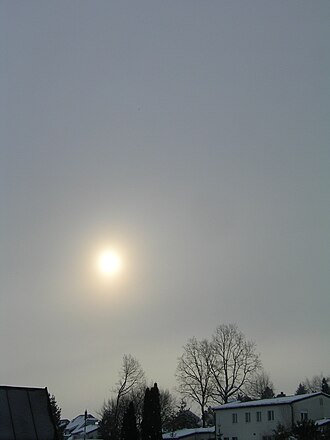
透光高层云:云体较薄,厚度均匀,呈灰白色,轮廓模糊。透光高层云无法掩盖天上的太阳或月球。
蔽光高层云:云体较厚,呈灰色,云底可见明相间的条纹结构,无法看出其轮廓。蔽光高层云可以掩盖天上的太阳或月球。
以上内容摘自维基百科「高层云」,按 CC BY-SA 4.0 使用,去掉了参考文献、外部链接等尾部小节,公式改写成了纯文本。全文、配图和出处见原文。
英文维基百科补充中文条目比较短,下面是英文条目「Altostratus cloud」的原文
Altostratus are middle-altitude clouds that develop horizontally and have a flat and uniform texture in the mid levels. As a middle-altitude cloud type, they can be made up of water droplets (including supercooled droplets), ice crystals, or a mixture of the two.
Altostratus clouds usually appear as gray or blueish featureless sheets, although some variants have wavy or banded bases. The sun can be seen through thinner altostratus clouds, but thicker layers can be quite opaque.
Altostratus clouds usually predict the arrival of warm fronts. Once altostratus clouds associated with a warm front arrive, continuous rain or snow may follow in the next 12 to 24 hours. While altostratus clouds may herald the arrival of wetter weather, they themselves do not produce significant precipitation, though they can produce sprinkles or light showers. Thunderstorms can be embedded in altostratus clouds, however, bringing showers.
Because altostratus clouds can contain ice crystals, they can produce some optical phenomena like iridescence and coronas.
Description
Altostratus clouds are generally gray or blue-tinged with a largely uniform blanket-like appearance. They do not have distinct features, and usually do not produce precipitation. The name "altostratus" comes from the conjugation of the Latin words "altum", meaning "high", and "stratus", meaning "flat" or "spread out". Altostratus clouds can produce virga, causing the cloud base to appear hazy. While they do not produce significant precipitation, altostratus clouds can cause light sprinkles or even small rain showers.
Formation
Altostratus clouds form when a large mass of warm air rises, causing water vapor in the atmosphere to condense onto nuclei (small dust particles), forming water droplets and ice crystals. These conditions usually happen at the leading edge of a warm front, where cirrostratus clouds thicken and lower until they transition into altostratus clouds. Alternatively, nimbostratus clouds can thin into altostratus. Altostratus can even form from the spreading of the upper anvil cloud or the middle column of a thunderstorm.
Use in forecasting
Altostratus clouds tend to form ahead of warm fronts or occluded fronts and herald their arrival. These warm fronts bring warmer air into the region. Occluded fronts form when a faster-moving cold front catches up to a warm front, and the temperature after the frontal system passes may rise or fall. As the frontal system approaches, cirrostratus clouds will thicken into altostratus clouds, which then gradually thicken further into nimbostratus clouds. If the frontal system is occluded, cumulonimbus clouds may also be present.
Effects on climate
Globally, clouds reflect around 50 watts per square meter of short-wave solar radiation back into space, cooling the Earth by around 12 °C (22 °F), an effect largely caused by stratocumulus clouds. However, at the same time, they reflect around 30 watts per square meter of long-wave (infrared) black body radiation emitted by the Earth back to Earth's surface, heating the Earth by around 7 °C (13 °F)—a process called the greenhouse effect. Cirrus and altostratus clouds are the top two sources of this heating effect.
Optical phenomena
Altostratus clouds can produce bright halos when viewed from the air, but not when viewed from the ground. Halos can take the appearance of rings, arcs, or spots of white or multicolored light and are formed by the reflection and refraction of sunlight or moonlight shining through ice crystals in the cloud. Light diffraction through altostratus clouds can also produce coronas, which are small, concentric pastel-colored rings of light around the sun or moon. They can also be iridescent, with often-parallel bands of bright color projected on a cloud.
Relation to other clouds
Altostratus and altocumulus clouds are the two genera of mid-level clouds that usually form between 2,000 and 6,100 m (6,500 and 20,000 ft). These are given the prefix "alto-". These clouds are formed from ice crystals, supercooled water droplets, or liquid water droplets.
Above the mid-level clouds are three different genera of high-level clouds, cirrus, cirrocumulus, and cirrostratus, all of which are given the prefix "cirro-". High-level clouds usually form above 6,100 m (20,000 ft).
以上节选摘自英文维基百科「Altostratus cloud」,按 CC BY-SA 4.0 使用,去掉了参考文献、外部链接等尾部小节,公式改写成了纯文本。篇幅所限,较长的小节只摘了开头一部分,有的小节没有收;全文、配图和出处见原文。